 Add Row
  Add
Add 


Understanding Severe Thunderstorm Warnings
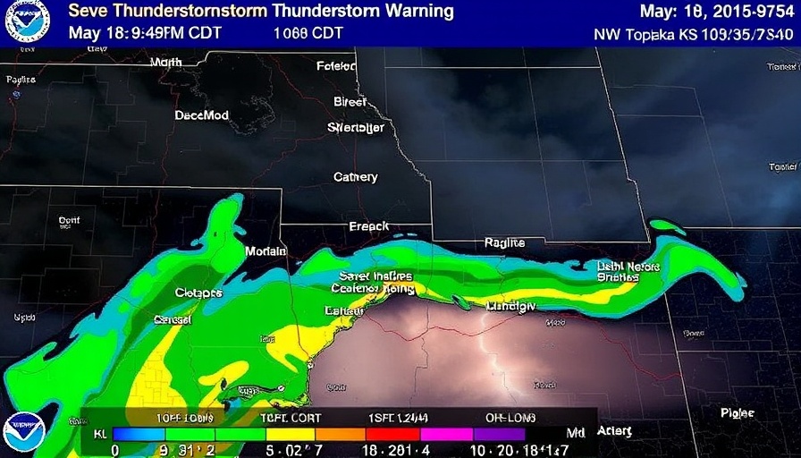
On May 18, 2025, the National Weather Service (NWS) issued a Severe Thunderstorm Warning for areas in Kansas, highlighting the seriousness of weather preparedness. Occurring at 9:48 PM CDT, this warning remained effective until 10:15 PM CDT, emphasizing the need for residents to take immediate action.
What to Expect During a Thunderstorm
According to radar reports, a severe thunderstorm was observed near Vermillion, moving northeast at 35 mph, capable of producing 60 mph wind gusts and quarter-sized hail. Residents in affected areas such as Seneca, Centralia, Axtell, and others were urged to seek shelter immediately. The potential for significant damage from hail to vehicles and winds affecting roofs, siding, and trees was outlined as key concerns.
Prepare and Protect Yourself
During severe thunderstorm warnings, preparation can make a vital difference. It is crucial for individuals outdoors to find a strong building, away from windows, to ensure safety. The impacts of such storms can be substantial, making awareness and readiness essential. Preparing for adverse weather conditions can include securing loose objects, ensuring your vehicle is parked safely, and having an emergency kit ready for any situation.
Why Weather Alerts Matter
Weather alerts are significant indicators of safety, especially in regions prone to extreme weather conditions. Staying informed through official channels such as local NOAA forecasts can provide real-time updates and guidance. Understanding these alerts is crucial in protecting lives and property.
Conclusion: Stay Vigilant
With the frequency of severe weather events increasing, being proactive can save lives. Whether you are a seasoned resident or new to storm-prone areas, knowing how to respond to weather warnings is imperative. Always remember to stay informed and ready for any upcoming severe weather.

 Add Row
  Add
Add 
Write A Comment