 Add Row
  Add
Add 


Severe Thunderstorm Hits Indiana: What You Need to Know
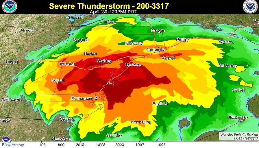
On the evening of April 30, a severe thunderstorm warning was issued by the National Weather Service (NWS) Indianapolis, alerting residents in southern Jennings County to take immediate action. The warning, which was effective from 9:20 PM to 10:00 PM EDT, indicated that a severe thunderstorm was detected moving east at a speed of 25 mph. With reports of 60 mph wind gusts and quarter-sized hail, the potential for damage to vehicles, roofs, and trees was highlighted.
Understanding the Impact of Severe Thunderstorms
Severe thunderstorms can lead to a range of hazards, including damaging winds, heavy rain, and hail. As seen in this warning, the specific threats include wind gusts that can uproot trees and hail that can dent cars or injure pets outdoors. Communities like North Vernon, Vernon, and Paris Crossing were notably impacted by the impending storm.
Preparedness is Key
As indicated in the alert, residents were advised to move to an interior room on the lowest floor of their homes. During severe weather events, following safety protocols can significantly reduce the risk of injury. It’s crucial for individuals to stay tuned to local weather updates and alerts to remain informed.
Weather Dynamics in Indiana
This severe thunderstorm warning is a part of a broader weather pattern in Indiana that includes a tornado watch also in effect until 11:00 PM EDT. Such conditions serve as a reminder of the volatile nature of spring weather in the Midwest, emphasizing the importance of being weather-aware during this time.
Conclusion: Stay Safe
The recent warnings serve as a powerful reminder of nature's unpredictability. Communities are encouraged to stay vigilant, prepare for possible evacuations, and keep emergency supplies handy. Understanding the threats that storms pose can empower individuals to take proactive steps to ensure their safety.

 Add Row
  Add
Add 
Write A Comment